
Introduction: Your Ultimate Guide to the Grand Canyon South Rim
The Grand Canyon National Park is a world-renowned natural wonder, but with a canyon this vast, first-time visitors often ask: Where should I begin? The answer, for over 90% of the park’s visitors, is the spectacular Grand Canyon South Rim.
Why the South Rim is the Most Popular Grand Canyon Destination
The South Rim, open 24 hours a day, 365 days a year, is the most developed and visitor-friendly section of the entire park, making it the top choice for a classic Grand Canyon experience.
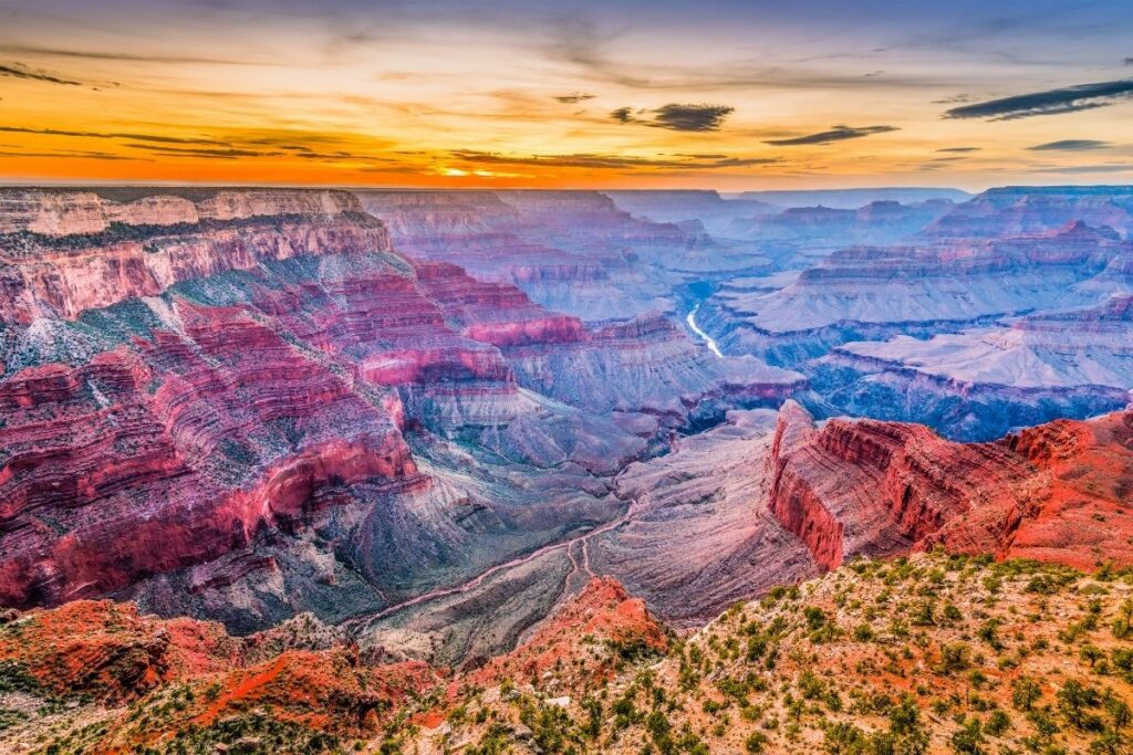
- Iconic, Expansive Views: This rim offers the most recognizable, deep, and layered panoramic views of the Canyon, often including the Colorado River twisting along the bottom. The South Rim’s elevation and proximity to the river create the dramatic, sheer-drop vistas seen on postcards.
- Accessibility and Services: Located closest to major cities like Phoenix and easily accessible via I-40, the South Rim features extensive infrastructure. It is home to Grand Canyon Village, which provides historic lodging (like the famous El Tovar Hotel), multiple dining options, visitor centers, and a convenient free shuttle bus system to move you seamlessly between viewpoints.
- Best Hiking Access: It is the starting point for the Grand Canyon’s two most famous inner-canyon trails: the Bright Angel Trail and the South Kaibab Trail.
Table of Contents
What to Expect on Your South Rim Visit
A trip to the South Rim offers a perfect balance of awe-inspiring nature and visitor convenience:
| Category | What You Will See & Experience | Must-See Attractions |
| Views | Expansive, multi-layered geological formations; the deepest point of the canyon; dramatic sunrises and sunsets. | Mather Point, Yavapai Point & Geology Museum, Hopi Point (best for sunset). |
| Trails | Paved rim-side walks and challenging trails descending into the canyon. | Rim Trail (easy, paved, 13+ miles), Trail of Time (easy, geological walk), Bright Angel Trail (descent into the canyon). |
| Attractions | Historic architecture, educational exhibits, and family-friendly activities. | Desert View Watchtower, Kolb Studio, Ranger-led programs, and the Grand Canyon Railway experience. |
Whether you plan to hike below the rim, ride a mule, or simply soak in the epic scale from a paved viewpoint, the South Rim provides the perfect starting point for your Grand Canyon adventure.
Top Things to Do at the Grand Canyon South Rim
To truly appreciate the breathtaking scale and dramatic beauty of the Grand Canyon, your first order of business is visiting its premier scenic outlooks. The South Rim is famous for having the most accessible, expansive, and photographable viewpoints in the entire park.
1. Visit the Iconic Viewpoints
The three most essential viewpoints on the South Rim each offer a unique perspective on the canyon’s geology, depth, and sheer magnitude.
Mather Point (The Grand Introduction)
For most first-time visitors, Mather Point is their first unforgettable glimpse of the Grand Canyon. Its proximity to the main Grand Canyon Visitor Center and the large parking area makes it the most accessible and busiest overlook.
- The View: A vast, overwhelming panorama that captures the sheer width of the canyon, stretching over ten miles to the North Rim. You can clearly see the distinct, colorful layers of rock—Kaibab Limestone, Coconino Sandstone, and more—stacked in geologic time.
- Why Visit: It’s the quintessential “wow” moment. The large, railed overlooks project you out over the abyss, providing incredible photo opportunities, especially during sunrise and sunset when the light transforms the canyon’s colors.
Yavapai Point & Geology Museum (For the Curious Mind)
Located just a short walk (or a quick shuttle ride) west of Mather Point, Yavapai Point is considered the premier spot for understanding the canyon’s geological story.
- The Museum: Housed in a historic 1928 structure, the Yavapai Geology Museum features large picture windows that frame specific rock formations. Annotated displays help you identify and understand the various rock layers and fault lines visible from the rim.
- The View: This is arguably the best point to see the Colorado River far below as it snakes through the Inner Gorge. Geologists love this spot because it offers a direct, unobstructed view of almost every major geological feature in the canyon, earning it the nickname “the key to the Grand Canyon.”
Desert View Watchtower (The Panoramic Eastern Vista)
Perched on the eastern edge of the South Rim along the scenic Desert View Drive, this destination offers a dramatically different perspective.
- The Architecture: The 70-foot Desert View Watchtower is a National Historic Landmark, designed by famed architect Mary Colter in 1932. She modeled the stone tower after the ancestral Puebloan architecture of the Southwest.
- The View: Climb the interior staircase (when open) for the highest and widest vantage point on the South Rim. From the top, you gain a spectacular 360-degree panorama that includes:
- The sharp bend of the Colorado River.
- The vast expanse of the Painted Desert to the east.
- Distant glimpses of the Navajo and Hopi reservations.
- Cultural Highlights: The tower’s interior features fascinating murals by Hopi artist Fred Kabotie, depicting Hopi mythology and their deep cultural connection to the canyon.
The Grand Canyon’s South Rim offers a variety of popular hiking trails, each with a different level of difficulty and unique views. Here’s a breakdown of the trails you’ve listed:
1. Bright Angel Trail
- Description: The Bright Angel Trail is one of the most well-known and popular trails in the park. It’s well-maintained and provides a good introduction to hiking into the canyon. The trail is tucked into a side canyon, which offers more shade and a higher chance of seeing a variety of plants and animals compared to the South Kaibab Trail.
- Difficulty: It is considered strenuous, especially if you hike a long distance. Remember that the way down is easy, but the hike back up is challenging. Plan for your return hike to take at least twice as long.
- Destinations & Features:
- 1.5 Mile Resthouse: A good turnaround point for first-time or casual hikers. The round-trip distance is 3 miles with an elevation change of about 1,100 feet.
- 3 Mile Resthouse: A more challenging day hike, about 6 miles round-trip with a 2,120-foot elevation change.
- Havasupai Gardens (formerly Indian Garden): A true oasis within the canyon, about 9 miles round-trip. This is a very strenuous day hike and should only be attempted by fit, experienced hikers.
- Plateau Point: A 12-mile round-trip hike from the rim, which offers an excellent view of the Colorado River. This is a very difficult and exposed hike.
2. South Kaibab Trail
- Description: The South Kaibab Trail is known for its spectacular, panoramic, and unobstructed views because it follows open ridgelines. It is a steeper and more direct route into the canyon compared to the Bright Angel Trail. There is very little shade and no water available on this trail, so you must carry everything you need.
- Difficulty: This trail is steep and strenuous, and the lack of shade and water makes it especially challenging in hot weather.
- Destinations & Features:
- Ooh Aah Point: A fantastic spot for a shorter hike and a great introduction to the inner canyon. It’s about 1.8 miles round-trip with an elevation change of 685 feet. The point is aptly named for the reaction it inspires in many visitors.
- Cedar Ridge: A popular turnaround point for day hikers, offering a large, relatively flat area to rest with pit toilets. The round-trip distance is about 3 miles with an elevation change of about 1,150 feet.
- Skeleton Point: The first point on the trail from which you can see the Colorado River. This is a more challenging day hike, about 5.6 miles round-trip with a 2,000-foot elevation change.
3. Rim Trail
- Description: The Rim Trail is perfect for easy walking and offers stunning views along the canyon’s edge without a steep descent. The trail stretches for about 13 miles from the South Kaibab Trailhead to Hermits Rest.
- Difficulty: The trail is mostly flat and paved, making it accessible for hikers of all levels, including families with strollers or those in wheelchairs in some sections.
- Features: You can choose to walk any section of the trail, and a free shuttle bus system runs along Hermit Road, allowing you to hike a portion of the trail and then ride the shuttle back. Highlights include Mather Point and Yavapai Point.
The three visitor centers/museums you’ve listed on the Grand Canyon’s South Rim each serve a distinct purpose, focusing on different aspects of the park experience:
1. Grand Canyon Visitor Center (South Rim)
- Main Purpose: This is the primary orientation hub for all South Rim visitors. It’s the best place to start your day.
- Location: Near Mather Point (central South Rim). It’s a major hub for the free park shuttle bus system.
- Key Features:
- Information and Planning: Large information desks staffed by park rangers to answer questions about trails, shuttle routes, lodging, and safety.
- Orientation Film: A theater that shows the park’s official film, “We Are Grand Canyon,” which is a great introduction to the canyon’s natural and cultural history.
- Exhibits: Outdoor and indoor exhibits, including permanent signs and displays in the plaza that offer trip-planning and hiking information.
- Amenities: Large parking lots (including for RVs), accessible restrooms, and a Grand Canyon Conservancy Park Store for books, maps, and souvenirs.
2. Verkamp’s Visitor Center
- Main Purpose: Focuses on the human history of Grand Canyon Village and the early pioneer/tourism era.
- Location: In the historic Grand Canyon Village, near the El Tovar Hotel and Hopi House.
- Key Features:
- Historic Building: Housed in a building originally constructed in 1906 as a curio and souvenir shop by the Verkamp family, one of the first businesses on the rim.
- Exhibits: Interprets the life of the Verkamp family, the development of tourism, and the evolution of the Grand Canyon community. A walking history timeline is often displayed on the floor.
- Setting: Its location in the Historic District makes it a great spot to appreciate the early architecture and atmosphere of the park. It also has a Grand Canyon Conservancy Park Store.
3. Yavapai Geology Museum
- Main Purpose: Dedicated to the geological history and formation of the Grand Canyon.
- Location: At Yavapai Point, one of the most famous and panoramic viewpoints on the South Rim.
- Key Features:
- Panoramic Views with Annotation: The museum’s main room features huge picture windows with annotated displays that help you identify the distinct rock layers and formations visible from that spot.
- Geology Exhibits: A large, three-dimensional topographic relief map of the canyon, and exhibits that explain the rock column, erosion, and the carving of the canyon by the Colorado River.
- Trail of Time Access: It is the starting point (or ending point) for the Trail of Time, a 2.8-mile outdoor interpretive path that places you on a geologic timeline of the canyon’s formation.
- Ranger Programs: Often hosts ranger-led geology talks and is one of the best spots for sunrise/sunset viewing.
The Grand Canyon’s South Rim shuttle bus system is a highly efficient and free transportation network that serves as the backbone for exploring the most popular areas of the park.
Free Shuttle Routes
The South Rim shuttle system generally operates a few core routes, though exact schedules and routes can change seasonally (always check the official NPS website upon arrival). The main routes are:
| Route Name | Color | Main Purpose | Key Stops |
| Kaibab Rim Route | Orange | Access to eastern viewpoints & South Kaibab Trailhead. | Grand Canyon Visitor Center, Mather Point, Yavapai Geology Museum, Yaki Point, South Kaibab Trailhead. |
| Village Route | Blue | Connects the main village services. | Grand Canyon Visitor Center, Market Plaza (store, post office), Lodges (Bright Angel, El Tovar, Maswik), Backcountry Information Center, Hermits Rest Route Transfer. |
| Hermits Rest Route | Red | Access to western scenic viewpoints. | Hermits Rest Route Transfer, Trailview Overlook, Maricopa Point, Hopi Point (sunset viewing), Mohave Point, Pima Point, and Hermits Rest. |
| Hiker’s Express | (No Color) | Early morning service for inner-canyon hikers. | Bright Angel Lodge, Backcountry Information Center, Grand Canyon Visitor Center, South Kaibab Trailhead (very early departures). |
| Tusayan Route | (Purple – Summer Only) | Park-and-Ride service from the town of Tusayan. | Various stops in Tusayan, drops off at the Grand Canyon Visitor Center. |
Why the Shuttle is the Best Way to Explore
Riding the free shuttle is strongly recommended for most visitors because it addresses the park’s biggest logistical challenges: traffic and parking.
- Access to Restricted Areas:
- Hermit Road (Red Route): During the busiest season (generally March through November), Hermit Road is closed to all private vehicles. The Red Route shuttle is the only motorized way to access these nine spectacular western viewpoints, including the famous sunset spots like Hopi Point.
- South Kaibab Trailhead (Orange Route): This trailhead is not accessible by private vehicle. You must take the Orange Route or the Hiker’s Express shuttle to begin your hike here.
- Solves Parking Headaches:
- Parking lots in the Grand Canyon Village area and at popular viewpoints like Mather Point and Yavapai Point fill up very quickly, especially during peak season. By parking at the main Visitor Center Plaza, you can leave your car once and use the reliable shuttle system to reach virtually every point of interest, eliminating the stress of finding parking multiple times.
- Efficiency and Convenience:
- Shuttles run frequently (every 15–30 minutes) and the routes are designed to connect seamlessly, allowing you to hop on and off at will.
- It allows you to travel one-way along the Rim Trail (the easy walking path) and then simply catch a shuttle back to your starting point, saving your legs for other activities.
- The buses are clean, accessible, and run on compressed natural gas, making them an environmentally friendly way to explore the park.
Taking a scenic drive is an excellent way to cover a large portion of the Grand Canyon’s South Rim, with two primary routes offering distinctly different experiences and access rules.
5. Take a Scenic Drive (South Rim)
A. Desert View Drive (AZ-64 East)
- Key Feature: The only major scenic drive on the South Rim open to private vehicles year-round (for its full length).
- Distance: Approximately 23 miles (37 km) one-way, traveling east from Grand Canyon Village to the East Entrance.
- What You Will See:
- The Colorado River: This route offers some of the best views of the Colorado River deep in the canyon.
- Desert View Watchtower: An iconic, 70-foot stone structure designed by architect Mary Colter, which you can often climb for panoramic views.
- Historic and Geological Points: You will pass by viewpoints that showcase unique geological layers (like Moran Point) and the Tusayan Ruin and Museum (an ancestral Puebloan archaeological site).
- Notable Overlooks:
- Grandview Point (historic trailhead with incredible views)
- Moran Point (best for geological perspectives)
- Lipan Point (excellent river views)
- Navajo Point (the highest overlook on the South Rim)
- Desert View Point (home to the Watchtower and services)
- Access: Driveable in your private vehicle, making it ideal for those who prefer to explore at their own pace.
B. Hermit Road Drive (Red Route)
- Key Feature: Known for having the most dramatic, up-close views of the inner canyon and the Colorado River.
- Distance: A 7-mile (11 km) stretch of road leading west from Grand Canyon Village to Hermits Rest.
- Access and Restrictions:
- Shuttle ONLY (March 1 – November 30): During the peak season, the road is closed to all private vehicles. Visitors must use the free Hermits Rest (Red) Route Shuttle Bus to access all the viewpoints.
- Private Vehicle Access (December 1 – February 28/29): Private vehicles are allowed to drive and park at the overlooks during the winter months when the Red Route shuttle service is suspended.
- Notable Overlooks (Accessible via the Red Shuttle Bus):
- Trailview Overlook (views of Bright Angel Trail)
- Hopi Point (a classic spot for sunrise and sunset)
- Mohave Point (great for seeing the river in the gorge)
- The Abyss (showcases the sheer vertical drop)
- Pima Point (listen for the roar of the Granite Rapids)
- Hermits Rest: The end of the road, featuring a historic stone structure and gift shop/snack bar, also designed by Mary Colter.
- Best for: Visitors seeking the most iconic canyon vistas and those who enjoy cycling or walking, as the Rim Trail parallels this entire road.
That’s a fantastic list of prime locations at the Grand Canyon’s South Rim for experiencing sunrise and sunset!
Here is some additional information about those spots, particularly regarding access, as that often requires planning:
Best Sunrise Spots
- Mather Point:
- Access: Very easy. It’s located near the Grand Canyon Visitor Center and the main parking lots. You can walk a short distance from the parking area. It is also a stop on the free Kaibab/Rim (Orange) Route shuttle bus.
- Crowds: Expect it to be one of the most crowded spots, especially in peak season, due to its accessibility.
- Yaki Point:
- Access: Not accessible by private vehicles most of the year. You must take the free Kaibab (Orange) Route shuttle bus from the Grand Canyon Visitor Center or Grand Canyon Village. You can also walk or bike the Rim Trail to get there.
- Vibe: Less crowded than Mather Point since it requires taking the shuttle, offering a slightly quieter experience. It offers expansive views to the east and west.
Best Sunset Spots
- Hopi Point:
- Access: Located on Hermit Road. Most of the year (March 1 through November 30), Hermit Road is closed to private vehicles. You must use the free Hermit (Red) Route shuttle bus to reach it. During the winter months (generally December 1 through February 28), Hermit Road is open to private vehicles.
- Crowds: It is widely considered the premier sunset location and, therefore, is very crowded, especially in summer.
- Mohave Point:
- Access: Also on Hermit Road, so access is the same as Hopi Point: Red Route shuttle bus most of the year, or private vehicle access only in the winter (December through February).
- Vibe: A bit less crowded than Hopi Point and offers excellent views of the Colorado River deep in the canyon.
Key Tips for Watching Sunrise/Sunset:
- Arrive Early: For sunrise, arrive at least 30 minutes before the official time. For sunset, arrive at least 60-90 minutes before to secure a spot, especially at Hopi Point in the busy season.
- Dress Warmly: The rim is over 7,000 feet (2,100 meters) elevation, and temperatures drop significantly before sunrise and after sunset, even in summer. Layers are essential.
- Stay Late: The most dramatic colors often occur 10-20 minutes after the sun has gone down, so don’t rush off immediately.
- Shuttle Time: Pay attention to the last shuttle time if you are on the Hermit (Red) Route, as you don’t want to miss the final bus back to the village after sunset. Shuttles usually run at least an hour after sunset.
Engaging with a Park Ranger or exploring the historical sites provides deeper insight into the Grand Canyon’s natural and human history.
Here is an overview of the Ranger Programs and the Tusayan Museum and Ruins:
Park Ranger Talks & Programs
Park Ranger programs are free and highly recommended for learning about the canyon’s geology, wildlife, history, and Native American cultures.
| Program Type | Typical Location/Focus | Key Info |
| Geology Talks & Walks | Yavapai Geology Museum and the Trail of Time. | These programs explain how the canyon formed, the different rock layers, and the immense scale of the canyon. |
| Cultural/History Walks | Grand Canyon Village Historic District (starting near Verkamp’s Visitor Center or El Tovar Hotel). | Easy walks focusing on the history of Grand Canyon tourism, the historic buildings, and early canyon explorers. |
| Evening Programs | McKee Amphitheater (summer/fall) or Shrine of the Ages (winter/spring). | Traditional “campfire” style programs with slides, covering topics from astronomy to wildlife to cultural history. |
| Guided Hikes | Often on the Bright Angel or South Kaibab Trail (like a hike to Cedar Ridge). | A great option for hikers who want a little guidance or do not want to hike alone. These are often offered in the early mornings during the summer. |
| Junior Ranger Program | Activity books can be picked up at Visitor Centers and Bookstores. | A fun and educational activity for children (ages 4-14). Upon completion, they are sworn in and receive a Junior Ranger badge. |
| Night Sky/Astronomy | Various spots, often in the evening. | Grand Canyon has some of the darkest skies in the country. Rangers lead programs that highlight constellations and planets. |
Tusayan Pueblo and Ruins
This site offers a glimpse into the lives of the Ancestral Pueblo people who inhabited the area centuries ago.
| Feature | Details |
| Location | Along Desert View Drive, approximately 3 miles (4.8 km) west of the Desert View Watchtower. |
| The Pueblo | The site contains the remains of a small, 800-year-old Ancestral Pueblo village, including outlines of several rooms and a circular kiva (a ceremonial room). |
| The Trail | A relatively flat 0.1-mile (200 m) self-guiding trail loops around the ruin. |
| Ranger Programs | Park Rangers often give short, free, guided tours of the Tusayan Pueblo site (check the schedule for current times, as this can vary by season). |
| Tusayan Museum | The adjacent museum, which once held cultural items and exhibits, may be temporarily closed. However, the outdoor ruins trail is generally accessible. |
Tip: Check the official National Park Service “The Guide” park newspaper or the online schedule when you arrive for a complete list of programs, times, and locations, as they change seasonally.
Biking is an excellent and popular way to explore the Grand Canyon’s South Rim, especially along the paved and scenic paths of the Greenway Trail.
Biking the Grand Canyon South Rim
- The Greenway Trail: This network of paved, non-motorized trails is safe and scenic. It connects the Grand Canyon Village area with key viewpoints.
- VC to South Kaibab Trailhead: An excellent paved section of the Greenway Trail connects the Visitor Center (VC) to Pipe Creek Vista and the South Kaibab Trailhead.
- VC to Tusayan: A 6.5-mile (10.5 km) paved Greenway section runs from the Grand Canyon Visitor Center south to the gateway town of Tusayan. This is a popular, mostly downhill ride from the park back toward the entrance.
- Hermit Road: This scenic road is closed to private vehicles for most of the year (mid-March to end of November), making it an ideal, safe, and breathtaking cycling route. The road is 8 miles (13 km) one-way and offers access to iconic viewpoints like Hopi Point and Hermit’s Rest.
Bike Rentals and Tours
- The Only In-Park Rental Shop: The main provider for rentals and tours inside the national park is Canyon Adventures Bike Tours & Café (formerly Bright Angel Bicycles).
- Location: Conveniently located at the Grand Canyon Visitor Center Plaza (near Parking Lot 4).
- Rentals: They offer a variety of rentals, including traditional cruiser bicycles, e-bikes (Class 1), children’s bikes, trailers, and tag-alongs. Rentals can be for a few hours or a full day.
- Tours: Guided bike tours are offered on popular routes like the Hermit Road and the path to Yaki Point.
- Shuttle Service: They can sometimes provide shuttle drops/pickups, allowing for an easy, one-way ride (like being shuttled to the top of Hermit Road and biking back).
Note: If you bring your own bike, the park’s free shuttle buses are equipped with bike racks, making it easy to cycle one way and take the shuttle back. E-bikes (Class 1 and 3) are generally allowed where traditional bicycles are permitted.
The Grand Canyon is home to a diverse array of wildlife, with elk, mule deer, and the majestic California condor being some of the most visible and sought-after sightings.
Common Grand Canyon Wildlife
- Elk: These large, beautiful animals are abundant on the South Rim, often seen grazing in the meadows near the Visitor Center, lodges, and campgrounds, especially at dawn and dusk. Caution is paramount as bull elk can be aggressive, particularly during the autumn rutting (mating) season.
- Mule Deer: Easily identified by their large, mule-like ears, they are common throughout the forested and rim areas of the park.
- California Condors: These critically endangered birds have been successfully reintroduced to the area. With a wingspan of up to
 feet (nearly 3 meters), they are magnificent to watch as they ride the thermal updrafts above the canyon. Look for them at viewpoints like Bright Angel Lodge, Hopi Point, and Hermit’s Rest.
Tips for Safe Wildlife Watching
For your safety and the well-being of the animals, follow these National Park Service guidelines:
| Safety Rule | Guideline | Why It’s Important |
| Maintain Distance | Stay at least 100 feet (30 meters)—about two bus lengths—away from large mammals (elk, deer) and condors. Stay at least 50 feet (15 meters)—about one bus length—away from smaller animals (squirrels, birds). | Animals that are approached may feel threatened and attack. It is also illegal to harass wildlife. |
| Never Feed Wildlife | Do not offer food, and ensure all food and trash are secured in designated containers. | Animals that get used to human food can become aggressive, which puts them at risk of being relocated or euthanized by park staff. Squirrels in particular can bite and transmit diseases. |
| Observe Quietly | Use binoculars or a zoom lens to get a closer look. Avoid making loud noises or sudden movements that could startle an animal. | Allows you to observe their natural behavior without causing stress or a dangerous reaction. |
| Watch the Road | Drive slowly and watch for animals crossing the road, especially at dawn and dusk when they are most active. | Vehicle strikes are a major danger for wildlife. |
| Keep Pets Leashed | All pets must be on a leash no longer than 6 feet and are generally not allowed on inner canyon trails. | Prevents disturbances and confrontations with wild animals. |
Lodging at the Grand Canyon South Rim offers a range of options, from historic lodges right on the rim to more modern hotels and campgrounds both inside and just outside the park. Staying inside the park is highly recommended for convenience and early access to viewpoints.
Lodges Inside Grand Canyon National Park (South Rim)
Xanterra Travel Collection operates all six lodges located directly inside the South Rim. These fill up quickly, often requiring reservations a year in advance.
- El Tovar Hotel: The most famous and historic lodge, located right on the canyon rim. It offers a fine dining experience and a classic national park feel.
- Bright Angel Lodge: A historic lodge offering both rustic cabins and lodge rooms right on the rim near the Bright Angel Trailhead.
- Kachina Lodge: Located directly on the rim between El Tovar and Bright Angel Lodge, offering modern rooms with some of the best views.
- Thunderbird Lodge: Also located on the rim between El Tovar and Bright Angel, offering modern, hotel-style rooms.
- Maswik Lodge: A large complex set back a short walk from the rim, offering contemporary and rustic rooms, a cafeteria, and a lounge.
- Yavapai Lodge: A large, modern lodge located near the Visitor Center and Market Plaza, offering easy access to the Greenway Trail and services.
Campgrounds
There are two major campgrounds on the South Rim:
- Mather Campground: Located in Grand Canyon Village, operated by the National Park Service (NPS). Reservations are essential and can be made up to six months in advance.
- Trailer Village RV Campground: Located in Grand Canyon Village, this is the only campground with full hookups and is operated by Xanterra.
Hotels Outside the Park (Tusayan)
The town of Tusayan, located just 7 miles (11 km) south of the South Entrance Station, offers several large hotel properties and is served by the park’s free shuttle system during the busy season.
Here are essential tips to help you plan your visit to the Grand Canyon South Rim.
Best Time to Visit
The South Rim is open year-round, but the experience and crowd levels vary significantly by season:
| Season | Best For | Weather & Crowds |
| Spring (March – May) | Excellent balance of good weather and moderate crowds. Great for hiking. | Weather: Mild, with daytime highs on the rim between 50∘F and 70∘F (10∘C to 21∘C). Be prepared for unpredictable weather, including wind or late snow. |
| Fall (Sept. – Nov.) | Widely considered the best time to visit for serious hikers and photographers. | Weather: Pleasant, with daytime highs on the rim between 60∘F and 75∘F (15∘C to 24∘C). Crowds decrease as the season progresses. |
| Summer (June – Aug.) | Long daylight hours and full park access (including the North Rim). | Crowds: Heaviest visitation of the year. Weather: Hot! Rim highs are in the $80^{\circ}\text{F}$s ($26^{\circ}\text{C}$s), but inner canyon temperatures can exceed 100∘F (38∘C). Thunderstorms are common. |
| Winter (Dec. – Feb.) | Solitude, low prices, and spectacular views of the canyon dusted with snow. | Crowds: Thinnest of the year. Weather: Cold, with rim highs in the $40^{\circ}\text{F}$s ($4^{\circ}\text{C}$s) and significant snowfall. Trails can be very icy and require traction devices (microspikes). |
What to Pack
Due to the elevation (7,000 feet / 2,133 meters at the South Rim), temperatures can fluctuate dramatically, sometimes 30∘F (17∘C) in a single day, and the sun is intense.
- Layers are Key: Bring clothing you can easily add or remove. Pack a moisture-wicking base layer, a mid-layer (fleece or light jacket), and a waterproof/windproof outer layer.
- Water: Crucial. Carry a reusable water bottle or hydration bladder. Plan to carry at least 2-3 liters of water per person, especially if hiking below the rim. Water availability on inner canyon trails is unreliable—treat all water or bring a filter.
- Sun Protection: Sunscreen (SPF 30+), sunglasses, a wide-brimmed hat, and lip balm with SPF are essential year-round.
- Footwear: Sturdy, well-broken-in hiking boots with good ankle support and traction. Bring hiking socks (wool or synthetic) and blister care (Moleskin).
- Hiking Gear: A daypack to carry your essentials, and trekking poles (highly recommended for stability and saving your knees on steep descents). In winter, carry traction devices (microspikes) for icy rim trails.
Entry Fees and Passes (7-Day Pass)
The pass allows unlimited entry to both the South and North Rims for seven consecutive days.
| Pass Type | Cost | Details |
| Private Vehicle | | Admits one non-commercial vehicle and all passengers. |
| Motorcycle | | Admits one non-commercial motorcycle and its passenger(s). |
| Individual | | Per person entering by foot, bicycle, park shuttle bus, or Grand Canyon Railway. Individuals 15 and under are free. |
| America the Beautiful Pass | | Annual pass for all U.S. National Parks and Federal Recreational Lands. A great value if you plan to visit multiple parks within a year. |
- Payment: Entrance stations do not accept cash; credit/debit cards are required. You can purchase a pass with cash or credit/debit cards at authorized pre-pay stations in the gateway town of Tusayan (e.g., Grand Canyon IMAX).
Accessibility Information
The Grand Canyon South Rim is generally very accessible, especially compared to the North Rim.
- Viewpoints: Many of the most popular viewpoints (Mather Point, Yavapai Point, Grandview Point, etc.) and facilities (Visitor Center, Lodges, and Museums) have designated accessible parking and paved, level paths to viewing areas.
- Rim Trail: A large portion of the Rim Trail—from the Grand Canyon Village area to Hermit’s Rest—is paved and generally flat, making it easily navigable by wheelchair or stroller.
- Shuttles: The free in-park shuttle buses are wheelchair-accessible (lift-equipped) and run frequently, making it easy to access many viewpoints and trailheads without moving your car.
- Restrooms: Accessible restrooms are available at all major developed areas.
Conclusion: Your Grand Canyon Adventure Awaits
The South Rim of the Grand Canyon offers a truly unforgettable experience, regardless of the season. To make the most of your trip, remember the key takeaways:
Recap of Top South Rim Activities
- Scenic Drives: Explore the numerous pull-offs on the Desert View Drive (open to private vehicles year-round) and take the free shuttle to the stunning viewpoints along Hermit Road (closed to private vehicles most of the year).
- Rim Walks: Enjoy the accessible and mostly paved Rim Trail, especially the scenic stretch from Mather Point to Yavapai Point.
- Iconic Views: Catch the sunrise at Mather Point or the sunset at Hopi Point for an explosion of canyon color.
- Historical Exploration: Visit the historic architecture of Grand Canyon Village, including the El Tovar Hotel and Mary Colter’s structures like Hopi House and Lookout Studio.
- Museums & Learning: Delve into the geology at the Yavapai Geology Museum and explore the ancient Tusayan Pueblo Site and Trail on Desert View Drive.
- Inner Canyon: For the fit and prepared, hike a small portion of the famous Bright Angel or South Kaibab trails to experience the canyon’s depth.
Plan Your Trip
Remember that the shoulder seasons of Spring (April/May) and Fall (September/October) generally offer the best combination of pleasant weather and manageable crowds. Pack layers, drink plenty of water, and prepare to be amazed.
Nearby Attractions and Gateways
The Grand Canyon is the centerpiece, but the area offers a full travel experience:
- Grand Canyon Village: Located right on the rim, this is the main hub for lodging, dining, historical buildings, and the trailheads for the Bright Angel and South Kaibab trails.
- Tusayan: Located just one mile south of the park’s entrance, this gateway town provides additional lodging, dining options, the Grand Canyon IMAX Theater, and a nearby airport for scenic helicopter tours.
- Flagstaff & Williams: These cities to the south are often used as base camps. Williams is the home of the historic Grand Canyon Railway, a unique way to enter the park, while Flagstaff is a larger city known for its dark skies and the Lowell Observatory.
Start planning your Grand Canyon adventure today to secure lodging and prepare for a truly monumental experience.